










Breaking News
 How War Propaganda Justifies Conscription Into Unjust Wars
 Trump's "Russian sanctions" Have Destroyed the German Automobile Industry
 Where are the headlines? 2026 is the 'First Time in 112 Years: No Atlantic Hurricanes By Sept. 2
 CNN Staffers Panic over Paramount Merger: 'Bloodbath Coming,' Newsroom Is 'Like a Funera
Top Tech News
 BEYOND THE MOON: NASA plans a nuclear-powered fleet to push DEEPER into space
 Big Oil Backs Mazama's $135 Million Bet On Superhot Geothermal
 Quantum compass takes flight on Northrop's Lumberjack drone
 Terrifying AI Behavior Even Its Creators Couldn't Explain
 WW3 Near-Miss? AI Hallucinated Nuclear Weapons Components Aboard Chinese Vessel Bound For Iran
 Stripe Is Building the Toll Road for the Machine Economy
 Toyota Dakar hopeful swaps twin-turbo V6 for hydrogen fuel cells
 4-min turbo-inflatable cubic camp castle is now available in the USA
 Researchers Used Claude To Hack OpenAI Employee Accounts
 Chinese Scientists Develop New Oil Refining Method That Cuts Energy Use by 90%



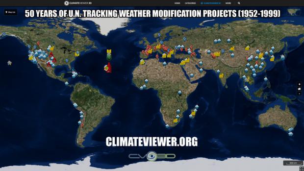
Map of U.N. Tracking Weather Modification Projects (1952-1999)
James Lee Interview (Hour 2): https://www.freedomsphoenix.com/Media/291077-2020-09-21-09-22-20-jay-noone-james-lee-diane-douglas-mp3.htm
MP3: https://www.freedomsphoenix.com/Media/Media-Files/687-0922192228-DYI2020-09-22.mp3
This documentary, in the form of a satellite map, traces the history of weather modification world wide between the years 1952 and 1999 as recorded by the United Nations World Meteorological Organization. This map includes data on the apparatus involved, agents applied and the techniques used in each event. It also includes both positive and negative results of some of the completed projects, funding sources such as government agencies and private companies. It even includes expert opinions and law cases on the topic in order for you to get a complete picture of the benefits and drawbacks of such programs. The apparatus, agent and characterizes data represents the first year of each program, any extended years of the program and in the case of US efforts lists the numbered NOAA documents for each extended year. The data involved in this map comes from the Register of National Weather Modification Projects 1989 through 1999 which are linked to this map.