


Breaking News
 Crypto Crackdown: Bitcoin Entrepreneur Entrapped by Feds
 Our Natural Predators
 Chemtrail Witnesses Are Being Killed - Conspiracy or are they hiding something?
 BREAKING: President Trump just revealed that Vladimir Putin told him our mail-in voting...
Top Tech News
 Chinese Scientists Produce 'Impossible' Steel to Line Nuclear Fusion Reactors in Major Break
 1,000 miles: EV range world record demolished ... by a pickup truck
 Fermented Stevia Extract Kills Pancreatic Cancer Cells In Lab Tests
 3D printing set to slash nuclear plant build times & costs
 You can design the wheels for NASA's next moon vehicle with the 'Rock and Roll Challenge
 'Robot skin' beats human reflexes, transforms grip with fabric-powered touch
 World's first nuclear fusion plant being built in US to power Microsoft data centers
 The mitochondria are more than just the "powerhouse of the cell" – they initiate immune...
 Historic Aviation Engine Advance to Unlock Hypersonic Mach 10 Planes
 OpenAI CEO Sam Altman Pitches Eyeball-Scanning World ID to Bankers


Hurricane Erin rapidly intensifies into catastrophic Category-5 monster storm:
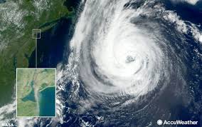
Hurricane Erin has quickly whipped into a catastrophic Category-5 monster storm travelling west across the Atlantic as the East Coast is warned of deadly water conditions.
The storm, sustaining winds of 160mph, is not expected to hit the United States, but heavy rainfall and dangerous water conditions are due to strike.
Swells from the hurricane are expected to cause 'life-threatening surf and rip currents' on the East Coast, as well as the northern Leeward Islands, the Virgin Islands, Puerto Rico, Hispaniola, the Turks and Caicos Islands, the Bahamas and Bermuda.
Depending on Erin's size and strength, waves could reach 30 feet or more, meteorologists warned.
'Families heading to U.S. Atlantic beaches for a late-summer vacation next week need to be extremely cautious when venturing into the surf,' AccuWeather lead hurricane expert Alex DaSilva warned.
'More than 50 people have lost their lives to rip currents and rough surf at beaches across the country so far this year, without any major hurricane nearby.'
Erin was upgraded to a Category-5 from a Category-3 storm on Friday evening. A Category-5 storm consists of winds above 157mph.
'By the middle of next week, Erin is forecast to at least double or triple in size, which will result in rough ocean conditions over the Western Atlantic,' the National Hurricane Center said.
'On the forecast track, the center of Erin is expected to move just north of the northern Leeward Islands, the Virgin Islands, and Puerto Rico over the weekend,' the hurricane center said.
Outer bands of the storm are expected to produce heavy rainfall until Sunday, with around two to four inches of rainfall. In some areas, around six inches is expected.
'Locally considerable flash and urban flooding, along with landslides or mudslides, are possible,' according to the NHC.
Hurricane Erin is expected to continue to strengthen, curving toward the East Coast and Bermuda.
'Fluctuations in intensity are expected for the rest of the weekend,' the hurricane center said.
AccuWeather warned that the worst-case scenario would see Erin guided directly onshore, 'packing high winds, flooding rain and storm surge flooding.'