


Breaking News
 Is 'Project Freedom' Just Another Trump Scam?
 THEY LIED About the Water - THE WELLS ARE GOING DRY GLOBALLY
 After Attack of Cargo Vessel, Trump Directs US to Escort Foreign Ships Through Hormuz
 RED ALERT: "I Think That You're Gonna See Billions Dead At This Rate!"
Top Tech News
 Robot Dives 1.5 Miles, Maps French Shipwreck With 86,000 Images And Recovers Artifacts
 Brain-inspired chip could reduce AI energy use by 70%
 CANCER HAS BEEN CURED
 "This is the first synthetic species," microbiologist J. Craig Venter told 60 Minutes'
 Humanoid robots are hitting the factories at an increasing pace
 Microsoft's $400 Billion Mistake Is Now a $200 Phone With Zero Tracking
 Turn Sand to Stone With Vinegar. Stronger Than Steel. Hidden Since 1627
 This is a bioprinter printing with living human cells in real time
 The remarkable initiative is called The Uncensored Library,...
 Researcher wins 1 bitcoin bounty for 'largest quantum attack' on underlying tech


Relics of 'lost continents' hidden under Antarctica are revealed-
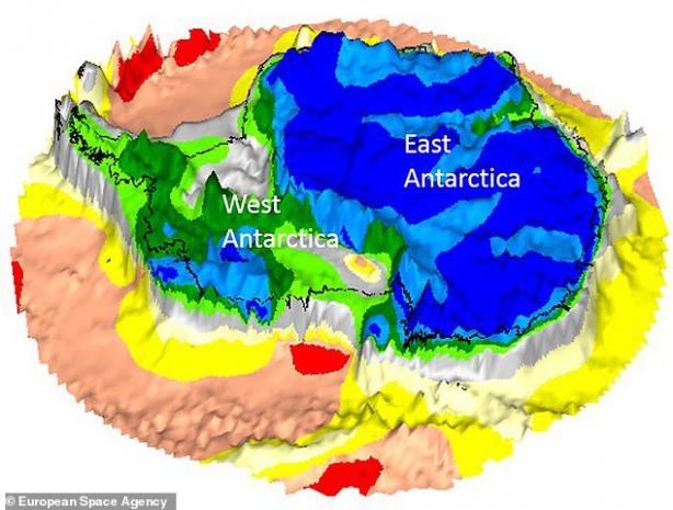
Images reveal a timeline of the ancient landmasses buried beneath Antarctica
They were taken by the long-dead Gravity field and Ocean Circulation Explorer
The ESA satellite collected data on Earth's gravitational pull
The European Space Agency (ESA) has uncovered relics of lost continents that have hidden under Antarctica for millions of years.
Satellite images reveal a timeline of the ancient landmasses buried a mile (1.6 km) beneath the icy continent.
Scientists said the snaps shed new light on Antarctica, the 'least understood continent on Earth'.
They used data from the long-dead Gravity field and Ocean Circulation Explorer (GOCE), which plummeted into Earth after it ran out of fuel in 2013.
While the satellite has been out of action for five years, scientists are still pouring over reams of data it collected on Earth's gravitational pull.