


Breaking News
 South Korea's currency just hit its weakest level since the 2008 financial crisis.
 While the world races to put AI into classrooms, Norway just decided to pull it out.
 BREAKING: Iran's Speaker of the Parliament says President Trump "falsely claims"...
 JUST IN -- The U.S. House has unanimously passed a resolution directing the House Ethics...
Top Tech News
 World's first hotel entirely staffed by robots to open in 2027
 Researchers in China are ignoring bug spray, citronella, and netting.
 Our bodies may be able to regrow lost limbs after all
 Chinese cars go blacker than black via hybrid nano tech
 World first: Human embryo model grows its own organs – in the lab
 Dead lithium batteries revived to 95% capacity via electrochemical bath
 Compact laser engraver levels up your DIY crafts setup
 'Groundbreaking' Potential Lupus Cure Sends Patients into Remission, Allowing Dreams...
 Speculations on What Could Show Physics Beyond the Standard Model
 SpaceX Orbital Travel and Orbital Hotels Need Starfall – Getting Back Safe and Cheap is Exciting


NOAA's Tiny Boat Drones Map The Ocean's Shallow Floors
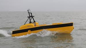
What shore knows not our maps? Most of them, it turns out. While satellites map much of the globe on a daily basis, there are parts of the planet so small and changing that they're tricky to pin down exactly. NOAA, America's National Oceanic and Atmospheric Administration, makes maps that anyone who navigates the sea can use, and to get the fine details on little inlets right, they turn to…
"Autonomous Surface Vehicles," also known as sea drones and (at least at Popular Science) as Roboats. While much of NOAA's sea plotting is done by ships, the smaller robots can swim to shallow inlets and areas, capturing parts of the ocean otherwise unknown. Using sonar and other measures, they plot the topography of the ocean floor, including details like sandbar shifts. Or, in other words, with sound they sound out the details of sounds.